MAP of Racine-Sturtevant Trail east end
 |
|
| Racine-Sturtevant Trail, west end | |
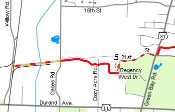
The Racine-Sturtevant trail doesn't quite make it to Sturtevant -- yet -- though with plenty of planned expansions, the trail will someday become a jewel of Racine County's trail system. "Phase 1A" extends from West Blvd. in Racine, where it also meets the junction of the City of Racine's Root River Pathway and the Racine County North Shore Trail, to the corner of WIS-31/Green Bay Road and 21st Street. "Phase 1B", reached via an on-street connection on 21st Street and Loni Lane, extends from the corner of Loni Lane and Regency West Drive in Mount Pleasant to Willow Road, at a location known as "Waxdale". By the time the trail is complete, it will end somewhere west of I-94, possibly even connecting to the trail currently planned for the former rail corridor west of Kansasville!
 |
|
| tree/trail | |
 |
|
| Do Not Enter | |
 |
|
| Do Not Enter | |
Trail surface/Conditions
The trail is paved with asphalt from West Blvd. to Green Bay Road, and is currently gravel-surfaced between Loni Lane and Willow Road; however, "Phase 1B" still has some work yet to be done, and will likely be asphalt-paved as well. Oakes Road is being constructed right in the middle of the trail, which further disrupts the continuity of the trail.
Trail History
All of "Phase 1" generally follows the right-of-way of the former Milwaukee Road (railroad) line that once stretched from downtown Racine to Savanna, IL. The rail line east of Waxdale was abandoned in the early 1980s, as much of the industry along the line closed or turned to alternative transportation. Much of the line remained dormant for almost 20 years, though some parts of the right-of-way were obscured by building and street projects. In 2001, Racine County built the Racine-Sturtevant Trail, connecting to the north end of the North Shore Trail and the new Root River Pathway.
The Trail
Between West Blvd. and Lathrop Ave., the trail is paved atop the former rail line. At Lathrop Avenue, an overpass once carried the tracks over the street, however, the dip in the street was prone to flooding. As a result, it was removed, and the street partially raised, in the mid-1990s. So, the trail crosses the street at grade, with a little meander down the embankment on either side of the street.
 |
 |
 |
|||
| more trail | trail | trail | |||
 |
 |
 |
|||
| Cozy Acre Road | Cozy Acre Road | trail | |||
 |
 |
 |
|||
| violets | trail | obstruction | |||
 |
 |
 |
|||
| Oakes Road | Oakes Road | Oakes Road | |||
Between Lathrop and Ohio Street, the trail swings to the north, moving closer to Republic Avenue. At Ohio Street, according to the Racine County description, there is supposed to be a marked connection to Pritchard Park (¼ mile to the south); however, I did not see such a connection the last time I explored this trail.
West of Ohio Street, the trail goes closer to following the former rail line, but meanders back and forth across the right-of-way. In my opinion, a connection to Roosevelt Avenue (and the back side of Regency Mall) would be beneficial, but one does not exist. After meandering around a power substation, the trail parallels Green Bay Road for a short distance before ending at the corner with 21st Street.
Unless you know where to go from here, you'll probably be wondering, "Is there more trail than this? Where do I go now?" (Just like I wondered myself the first time I biked the Racine-Sturtevant Trail!) Well, yes, there is more trail, it's just not done quite yet! If you're feeling brave enough to explore the rest of the trail, continue west on 21st Street. At the end of 21st Street, you'll see a gravel path continuing west; DO NOT follow this road, it is a private construction road! Instead, turn left on Loni Lane. At the intersection of Loni and Regency West Drive, the trail continues to the west.
I should probably warn you here, I don't think this part of the trail is open yet, so explore it at your own risk! At the time I explored this part of the trail, there was not yet a cutout in the curb for the new trail; unless you can clear a 4" curb, you'll need to stop and climb over it. From here, the trail goes down a slight hill and makes a right turn just inside a plantation pine forest. In the middle of the forest, the trail crosses Cozy Acre Road. Heading out of the forest, the trail angles behind the Case tractor plant and back onto the former rail line, which it follows all the way to Waxdale.
 |
 |
||
| trail | rail spur | ||
 |
 |
||
| bridge | rail spur | ||
 |
 |
||
| trail | RR xing | ||
 |
 |
||
| the end | the end | ||
The trail then crosses Oakes Road, or at least what will be Oakes Road when construction is complete. (As of the time I finally post this, Oakes Road is open.) A short distance to the west, about a half-dozen covered hopper cars can be seen on a rail spur to the south. This rail spur parallels the trail to Waxdale, where it connects with the Union Pacific's Milwaukee Subdivision. The trail then crosses Pike River on the old railroad trestle, updated for bike trail use; the rail spur's modern bridge can be seen to the south. Just before Willow Road, the trail crosses the Union Pacific at grade. The crossing is unsignaled, with only a stop sign, though a document filed with the Wisconsin Office of the Commissioner of Railroads indicates that some additional signage may be added here. At Willow Road, the trail ends.
Future Expansion
West of Willow Road, the rail line is in place as far as Kansasville, so it is not likely that the trail will continue along the right-of-way. Some discussed plans indicate that the trail will head north along Willow Road, probably along the generous bike lanes, to 16th Street, and continuing west along Rayne Road. But, with Phase 1B not yet complete, I expect that it will be a few years before any further construction is complete.
As for the rail corridor, there are two other trail segments along its abandoned parts, with a third in the works. Beyond the end-of-track in Kansasville, a trail is planned to connect to Burlington, and to the Seven Waters Trail. West of Burlington, beyond a short stretch of track still operated by Canadian National, the White River State Trail follows the former rail line to Elkhorn. Beyond Bardwell Jct., where Wisconsin & Southern's branch connects to its main line, the Pelishek Nature Trail runs between Allens Grove and Clinton, where Union Pacific picks up ownership of the rail line.
Hope you enjoy the Racine-Sturtevant Trail! Feedback and comments are welcome: Use my Contact page, or join the discussion on The Fuzzy World 3um. (NOTE: I explored this trail in May and June of 2008, and wrote this guide in June 2008, so some information here may be slightly outdated.)
-MH
Click here to start viewing the photo album, or click on a thumbnail above. Press F11 to toggle full-screen view (in most browsers).
UPDATE 11/13/2014: Julie wrote in to ask:
Hi - ... you wrote about how the [Racine-Sturtevant] trail ends on Willow Road. That was in 2008. Has it gone any farther West? Can I park somewhere on Willow [Road] near Waxdale and pick it up? THANKS!!!
In the past year or two, the trail has been expanded to follow Willow Road to the north (via bike lanes), then branches off north of Waxdale on the west side of Willow Road. The off-road trail then turns west on the north side of 16th St, crossing 90th Street and parallelling the south side of Rayne Road before ending at (IIRC) 96th St. Another trail starts up on the west side of Wisconsin Avenue, connecting to the depot platform and elevator tower. Another network of trails starts up just south of the Amtrak depot, with the westernmost trail connecting to West Road via the Gateway Technical College campus.
You should be able to park on most of the Renaissance Industrial park roads, Rayne Road, or even 16th Street; I believe parking is also available on Willow Road as well.
I've been working on an update to the map(s) and guide for most of the summer, hopefully I can get it wrapped up and on my website by early next year. Additionally, the railroad tracks heading west out of Sturtevant are being abandoned beyond Renaissance Blvd, which will provide an easy link between the Racine-Sturtevant Trail and the White River State Trail west of Kansasville! The updated map will indicate the new status of the railroad, and also feature a map of the Pike River Pathway to the north of the Racine-Sturtevant Trail area.
