April 29, 2007
the "extra-long way" to work!
Beginning Mileage: 1466.6
Ending Mileage: 1498.5
Total Mileage: 31.9
I decided to leave for work plenty early, and take the "long way" – actually, since it was a beautiful day and I wanted to be outside, I decided to explore one of the newer sections of the Oak Leaf Trail in Franklin. To get there, however, I needed to bike some of the roads...
![]() I started out from my subdivision, and headed south on 13th Street. Some clouds to the west seemed to threaten rain, though oddly enough, the only raindrops I felt were when I was under clear sky just before I turned onto Edgerton Avenue. Edgerton Avenue is under construction, and was one-way westbound. (A 13th District newsletter that I have since received indicates that Edgerton is receiving "traffic calming" narrow spots on the street. While this is probably a good thing for pedestrians, I wonder how this might affect any bicyclists that use the street?) At 20th Street, I turned left/south, negotiating the orange barrels blocking most of the intersection. 20th Street at this point is part of the city bike route as far south as Grange Avenue, and the road is equipped with bicycle lanes, which are rather nice. It also helps that 20th Street was recently paved.
I started out from my subdivision, and headed south on 13th Street. Some clouds to the west seemed to threaten rain, though oddly enough, the only raindrops I felt were when I was under clear sky just before I turned onto Edgerton Avenue. Edgerton Avenue is under construction, and was one-way westbound. (A 13th District newsletter that I have since received indicates that Edgerton is receiving "traffic calming" narrow spots on the street. While this is probably a good thing for pedestrians, I wonder how this might affect any bicyclists that use the street?) At 20th Street, I turned left/south, negotiating the orange barrels blocking most of the intersection. 20th Street at this point is part of the city bike route as far south as Grange Avenue, and the road is equipped with bicycle lanes, which are rather nice. It also helps that 20th Street was recently paved.
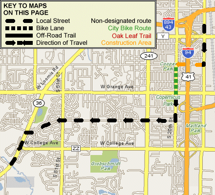
Beyond Grange, 20th Street is just a local street, though traffic is low enough, and the road wide enough, that it is a nice street to bike on. Between Klein Avenue and Ramsey Avenue is a rather large hill, which provided a nice challenge. Turning right/west onto Ramsey, I was greeted with another hill up to 23rd Street! Ramsey was downhill to 27th Street, and I hoped that I would be able to sail right through the intersection -- but I had to wait for a red light. (Thinking about this later, I should have turned on Klein Ave. -- just south of Copernicus Park -- and then navigated my way onto Parnell Avenue, which connects with Ramsey at 37th Street. And doesn't have quite the hill that I had to climb!) Ramsey makes its way slightly upgrade out of the Honey Creek valley, but works its way back downhill into the Root River valley as it approaches Loomis Road/WIS-36.
I then turned left/southwest onto WIS-36. Loomis Road is a very busy four-lane state highway, but the paved shoulders are wide and easily and safely accomodate bicyclists. Loomis Road connects with the Oak Leaf Trail at Root River Parkway, and the Oak Leaf Trail follows WIS-36 to 68th Street. Unfortunately, due to some overly-ambitious maps, I thought that the new paved trail that I wanted to explore came off the south side of Loomis Road someplace, so I had to circle around for a bit looking for it, before finally deciding to head down to 68th Street to look for it! I continued south on 68th Street for a short distance before finding the parking lot for the new paved trail about 1/4 mile south of 36. Looking at Craig Holl's site (Oak Leaf Trail extensions^), the trail connection on WIS-36 that I was looking for is apparently still planned, but has not yet been built!
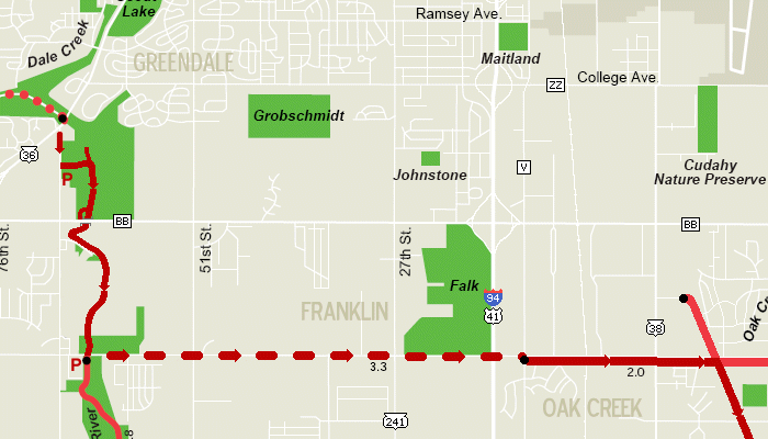
I turned onto the new trail, and headed down to the river. A short segment of trail branches off the main trail near where it turns south to follow the Root River, this segment is likely the beginnings of the eventual connection directly to the end of the Root River Parkway. It currently ends in a "cul-de-sac"... Continuing south on the trail, it follows the Root River, which is considerably better than the former route along 68th Street, which was rather narrow and hilly -- the old route has actually been "decommissioned" from the Oak Leaf Trail system!
The trail ducks under the Root River bridge on Rawson Avenue, though a path also leads up to Rawson itself. The trail then crosses a bridge over a marsh/flowage, and takes a turn to the east, going in between a private road and the river. A point of interest along the stretch of the trail between Rawson and Drexel is the Vulcan quarry across the river, which is partially visible from the trail at several points.
At Drexel Avenue, the option exists to continue south on the trail to Froemming Park and the county Sports Complex; this trail will eventually connect to the rest of the Oak Leaf Trail through the Root River Parkway that currently ends at Howell Avenue. However, since I was heading to work "the long way", I turned left onto Drexel Avenue, which is also designated as the Oak Leaf Trail. The stretch of Drexel between 27th Street and 13th Street is rather rough and narrow, as I had mentioned before in my November 7, 2003 Bicycling Journal. Beyond 13th Street, the Oak Leaf Trail utilizes an off-road trail that is more of a sidewalk than the asphalt-paved trails that are typical of the Oak Leaf Trail.
When I got to 6th Street, it was only 20:15 -- and I didn't need to be at work till 21:30 -- so I decided to head farther east, and bike the former Chicago North Shore & Milwaukee interurban line that is now part of the Oak Leaf Trail. I hadn't yet biked this entire trail since the tunnel under WIS-100 was completed, and I figured I could mark this portion of the Oak Leaf Trail off my "to-bike" list for 2007.
(To be continued...)