June 8, 2004
Oak Leaf Trail - Grange Avenue-Oklahoma Avenue
Beginning Mileage: 1343.0
Ending Mileage: 1352.2
Total Mileage: 9.2
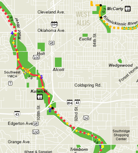 |
After work on a nice hot June afternoon seemed like the perfect time to check out yet another segment of the Oak Leaf Trail. I started where I had last left off, on the Root River Parkway at Grange Avenue (1), near Southridge Mall. The trail follows the parkway for about a mile before ducking under Layton Avenue on an off-road path (2). The trail returns to the parkway at 116th and Morgan Avenue.
This segment crosses several busy highways. The first is WIS-24 (Forest Home Avenue), a major divided highway that runs southwest to the Waukesha County border, where it continues to East Troy as County L. Next, the trail passes under Layton Avenue along with the Root River, but a paved path also intersects with Layton Avenue for those times when the Root River is flooded. A short distance later, the trail passes under the twin I-43/US-45 bridges over the Wimmer Wetlands.
The next major highway to cross the trail is WIS-100 (108th Street), the "loop" around Milwaukee County. A short distance northwest is County T (Beloit Road), which continues as County I in Waukesha County and goes as far as Mukwonago. Currently there is road construction on Beloit Road (shown by the orange "X"), and a detour has been fenced off with orange fencing. Unfortunately, the detour is surfaced with a very coarse gravel, making it difficult to bike over.
Finally, I turned around (mile 1347.6) (4) at Oklahoma Avenue, which connects National Avenue in Milwaukee County to National Avenue in Waukesha County. Although it is not signed as a highway, National Avenue was once the route of old WIS-15, which later moved south to what is currently I-43. Nonetheless, National Avenue is still a major road through this part of Greenfield/West Allis, and is extremely busy.
This part of the Oak Leaf Trail is extremely level, due mostly to its location along the Root River. The trail also travels through wetlands, which necessitates several bridges along the route. The most interesting bridge that I found is just east of WIS-100, where the bridge is the full width of a roadway (3)!!! I would assume that a continuation of the parkway was planned, but never fully built.
Happy Bicycling!!
-Mark