March 29, 2004
The Oak Leaf Trail in Franklin and Greendale
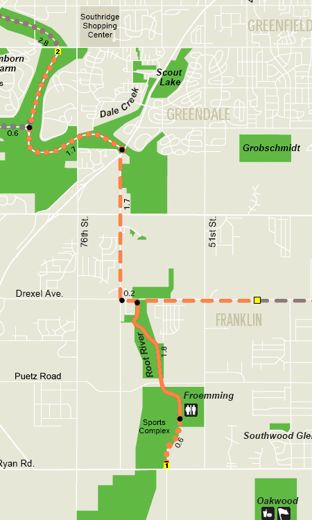
- Drexel Avenue
- Sports Complex Extension
- 68th Street
- Root River Parkway
Beginning Mileage: 1233.0
Ending Mileage: 1250.0
Total Miles Traveled: 17.0
 |
Ok, I'll admit it: I'm sick of winter, I can't wait for spring and summer, and I want to get outside and go biking!!!
Fortunately, today was just the right kind of day. After running some errands and chasing a few trains on Union Pacific's Kenosha Sub, I picked up my bicycle and headed for the Oak Leaf Trail, right where I left off last time, at 42nd and Drexel Avenue in Franklin.
Drexel Avenue is a moderately busy through route, but the wide paved shoulders make it a safe ride. The road is fairly hilly, however.
I rode about a mile and a half west, and turned left/south onto the Sports Complex Extension. This is a newer part of the Oak Leaf Trail system, added within the last 5-7 years. The trail is a paved trail, and generally follows the Root River south to the Milwaukee County Sports Complex north of 60th and Ryan Road. This easy-to-ride route is very scenic, and crosses three bridges, including an S-curved bridge over the Root River.
Being spring, the Root River has a habit of overflowing its banks, and I found standing water in several locations along the trail, but this was very insignificant. However, the trail ducks under Puetz Road along with the Root River, and here the trail was under water -- about a foot of water. Of course, I didn't figure this out until I rode about halfway through it, so my shoes ended up soaked for the rest of the trip!!
After returning to Drexel Avenue, I decided to continue the main trail route by turning north on 68th Street. There is one hill between the Sports Complex Extension and 68th Street on Drexel, and after turning onto 68th there is another hill!!! (Ugh!!!)
68th Street is very hilly. I certainly wouldn't recommend this road to the faint of heart!!! Despite being only 1½ miles, this was definitely the toughest part of my ride. Fortunately, Milwaukee County is planning a new off-road trail between the end of the Root River Parkway at Loomis Road and the Sports Complex Extension, along the Root River. I think a water-level route would be much more desirable to the average bicyclist. See details of this new trail on Craig Holl's website.
At the end of 68th Street, the trail follows Loomis Road for a short distance. I crossed Loomis (a busy 4-lane divided highway, WIS-36, 45-55 MPH) and used the very narrow sidewalk to get to the Root River Parkway, but there is an Oak Leaf Trail sign in the median on Loomis Road that has obviously been hit by a few cars and trucks... The new Root River trail will eliminate this dangerous stretch of the OLT as well.
I followed the trail on Root River Parkway as far as Grange Avenue before turning back. About ½ mile south of Grange, the Whitnall Loop diverges from the main trail, but I decided not to explore that today. Root River Parkway is scenic as well, with views of the Crystal Ridge Ski Area, and a large grassy area west of 76th Street where people practice golf.
On the way back to the truck, I decided to head south on 76th St. to eat at Taco Bell. There is a looooooonnnnnggggggg hill between the Root River and Loomis Road!!! On the other hand, there is a looonnnggg down-hill on Rawson Avenue between 76th and 68th Streets!!!
Well, it was a great first ride of the year, but I'll definitely have to get used to being on the bike again!!!
-Mark